🚐 Eclectic Historic Nova Scotia

I traveled to Nova Scotia in the summer of 2025. I am on a solo RV trip in my motorhome, Abeona. This was not my first time to Nova Scotia as my family traveled here in a tiny towable trailer when I was about 4. The only thing I remember about that trip is a picture that was taken by a canon and a bunch of men in kilts playing bagpipes. I have to say that I was truly expecting similar treatment when I arrived on my trip to Newfoundland in June but alas, was disappointed. No kilts. Worse yet no bagpipes. What I did find is an eclectic historic place full of beauty, seaside towns, fishing villages and, eventually, kilts. 

I first stayed near Cape Breton Island in Bras D’Or. I was heading on the ferry to Newfoundland by the end of the week and took the opportunity to explore the famously scenic Cabot Trail along the coast of Cape Breton Island. John Cabot who was a Venetian Italian explorer, Zuan Chabotto (John Cabot in English) was financed by Henry VII to explore North America.  He landed here in 1497. It’s believed that they were the first Europeans to North America after the Norsemen in L’Anse aux Meadow in 1014. Cabot Trail is a scenic drive with plunging coastline and fishing villages tucked in the bays. There were many craftspeople with storefronts along the way including a chocolatier, glass maker and eclectic restaurants. An odd thing here is that the signs on Cape Breton are all in Gaelic and English (no French except for National Parks). I knew I was returning to Nova Scotia after a month in Newfoundland so I saved the southern portions for my return trip.

Peggy’s Cove Lighthouse Nova Scotia

I also visited the Fortress of Louisbourg National Historic Site which is the rebuilt replica of an 18th century French colonial town. It’s really a trip back in time to walk past shops and bakeries from the 18th century with a large moat and fenced wall. People here are dressed in period costume of the French as it was a French fortress for 47 years after being founded in 1713.

Upon my return to Nova Scotia from Newfoundland, I headed to Halifax. As I have found in most larger cities, it’s difficult to navigate in a 24-foot motorhome. I randomly ended up on a bridge that was only for cars, I believe, and had no way to exit. I was quite nervous that I would be pulled over but it all went off just fine. I was headed to the Halifax Citadel and, although I had looked on Google for parking in advance, on a late sunny afternoon in July, parking is a premium. I finally found a spot, thankfully, so I didn’t have to abandon my trip to the Citadel. 

I was quite taken aback by the sheer size of the Citadel and its location in the heart of a bustling city with high rises and a shipping port. The Citadel itself has had four reincarnations with the first being in 1749.  This last fortification was built in 1828. Here finally I found men in kilts but alas, no bagpipes. I find it strange that although Nova Scotia means New Scotland in Latin,  the Scots where only here for 3 years (1629-1632). The Mi’kmaq people inhabited the region for several thousand years and then the French Acadian people came to establish the first colony in 1605. Then the British and French fought for the next few hundred years. It’s quite the eclectic mix of cultures. I was surprised to learn that Nova Scotia was almost the 14th colony during the American Revolution.  Even in the museums the information is in Mi’kmaq, English and French. The Citadel itself is a very nice intact fort. You can walk along the top of fortifications and it’s easily maneuvered. I was hoping for some long-hidden memory of this place assuming that it would have been important to my history loving father to visit but alas outside of a few canons and the kilts, nothing jumped out at me.

I headed to what is the most photographed lighthouse in Canada (and probably the world) at Peggy’s Cove. By now I’ve figured out that arriving at 9am at a touristy spot is paramount in order to park. I absolutely timed it perfectly. I was able to easily park and there were only one or two other tourists out there milling around so the pictures were perfect. The tiny cove with colorful houses and boats was so charming. The lighthouse itself is so special because it’s on an outcropping of granite that has been smoothed by glaciers and surrounded by the stunning Atlantic Ocean.  It truly is a terrific fishing village to walk through and has many eclectic shops like a pewter smith and art galleries.

I traveled up to Digby which is on the Bay of Fundy. Digby is renowned for their scallops. It was an adventure to travel up Digby Neck and take a ferry to Long Island which has the trail to Balancing Rock. This was quite the sight after hiking for close to a mile with nothing but boardwalk or trees and plenty of steps to suddenly see this enormous rock balancing precariously on the edge of a rock below. The rock formations along that coast reminded me of the Giant’s Causeway in North Ireland. Like someone deliberately made these enormous columns. 

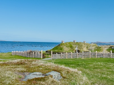
The most serendipitous discovery was of Fort Anne National Historic Site. There were several locations to visit around the oldest settlement in Nova Scotia called Annapolis Royal. It was happenstance that I stopped here and to my utter amazement I found a placard that placed my 9th Great Grandfather, Major Robert Sedgwick here in 1654. He was a Major and later General for Cromwell. He was the first to conquer Annapolis Royal in 1654 and at the time was a British born American merchant in Massachusetts. Cromwell just two years later sent Sedgwick to Jamaica to be the governor although he sadly died almost on arrival due to illness. Annapolis Royal has changed hands at least seven times between the English and French over a century. It is in a protected bay adjacent to the Bay of Fundy and was a critical location.

I stopped by Burntcoat Head Park as a last stop in Nova Scotia to walk on the seafloor. Here is the location for the world’s highest recorded tides. Twice a day 160 billion tons of water flow in and out of the Bay of Fundy with the highest tide reaching 53 feet. Luckily, I arrived at low tide and was able to take the steps down to the bottom of the ocean. It’s quite surreal especially with all the bright red iron rich sandstone that is molded like soft ice cream. It was another terrific stop.

I really enjoyed this trip to Nova Scotia with the sheer variety of things to do and see. There were plenty of things I didn’t have time to see and I’ll be sure to allocate more time next time. Whether it’s natural phenomenon, eclectic history or picturesque seascapes, this is the place to visit.

🧐25 Peculiarities of Newfoundland

I’m finishing up a month-long solo RV tour of Newfoundland.  This is truly a beguiling place with vast amounts of seascapes, cliffs, and wilderness as well as tiny fishing villages and busier hubs like St. John. The vast Great Northern Peninsula is as desolate in areas as the Yukon Territory with nary a Tim Horton (Canada’s answer to Dunkin); while St. John’s is a major shipping port with countless restaurants and museums. I began my trip at Port aux Basques where I could travel for hours without seeing any facilities and I am finishing up my trip outside of St. John’s which has 40% of the province’s population complete with parking garages and pedestrian thoroughfares. There is a lot of contrast here and I’ve loved every moment.

An iceberg near St. Lunaire-Griquet

Here are the 25 peculiarities of Newfoundland:

  1. Pronouncing it. I have been corrected on the pronunciation of Newfoundland by several Newfies. From the best I can figure it is pronounced: New-FUN-lAnd. I tend to say NEW-fin-lund. 
  2. No Newfoundland dogs.  Outside of statue of a Newfoundland and Labrador dog in downtown St. John’s, I have yet to see a Newfoundland dog here.  I had a client ask if there were herds of them here. There are not.
  3. Only Dairy.  Especially in the remote northern end of Newfoundland, I could not find any non-dairy milk or yogurt.  It’s all dairy, dairy here.
  4. Moose. I went to a nature park called Salmonair and traveled over 1,000 miles in Newfoundland. I have yet to see a live moose although they claim that there is one moose for every 4 people or 125,000 moose. That’s an amazing number considering they were introduced here in 1904.
  5. Icebergs. I saw eight icebergs on my trip here and if you come in June and are willing to travel to St. Lunaire or Twillingate, I can pretty much guarantee you will see an iceberg and it’s an awe-inspiring sight.
  6. RDF. A Newfie clued me in that this is the general term for weather which stands for Rain, Drizzle and Fog (St. John is known as Fog town). There is no telling when it will rain and when it will be sunny and, in general, the forecast is wrong. This can make planning difficult and you just have to be adaptable. 
  7. National Parks. There are two National Parks (Gros Morne and Terra Nova) on Newfoundland and they are beautiful and super inexpensive compared to the US. It’s only $11.00 to enter these parks for the day.
  8. Provincial Parks. I saw several Provincial Parks and all of them have been free. The most stunning was the Dungeon Provincial Park which is a collapsed sea cave.  It was a gravel road out to it, but when there is a clear, blue sky and pounding waves below in “the dungeon”, it’s a spectacular sight. 
  9. Potholes. When I drove the Alaska Canada highway last year there were always signs to indicate that potholes were coming and they were accurate. While the Trans-Canada Highway here is terrific, there are several secondary roads that were riddled with potholes and/or frost heaves (undulating roadway from temperature changes). Sometime I had to drive 20 miles an hour to make sure Abeona held together.
  10. Brogue. Many of the locals sound like they are from Ireland or Scotland. A server or customer service person would approach me and I must have had a deer in the headlights look because I have no earthly idea what they just said. Expressions like “Whaddayat” or “How ya gettin’on” at times made me think I was across the pond. 
  11. Chatty. I was mentioning to a Newfie I met in St. Pierre that people were so nice in Newfoundland and she said, “Well, they are really just chatty.” She is right. People would talk to me about just anything but most likely the weather (see #6).  I had an older man come up to me while I was gassing up Abeona and said, “Whaddayat” and “Come from away” (are you visiting).  He thought I had a really nice rig and asked “Do you have a man in there?” The folks here are chatty.
  12. Time zones. I think it’s bizarre but Newfoundland and Labrador are a half hour ahead of the Atlantic Time zone (Nova Scotia, etc.). So, they have their very own time zone.
  13. Gas. A lot of the gas stations only have regular gas and you pump and then pay inside. Similar to my trip through the Yukon, I gassed up at almost each gas station I found open (some are closed on Sunday).
  14. Potable water. I was prepared for this before I came but several campgrounds had boil warnings on the water. I had to be sure I filled up at the campgrounds with safe drinking water.
  15. Cover shopping carts return. I found it strange that grocery stores had covered places for the carts to be returned. Gas stations were not normally covered (like they are in the US). 
  16. Cod. Cod is the center of the universe here and when there was a moratorium on cod fishing starting in 1992 it devastated the region.  As they say here, fish is cod and cod is God. The fishing just restarted in 2024 but only partially. It’s why the area was settled 400 years ago.
  17. Jigg’s Dinner.  This is a classic Sunday dinner in Newfoundland and is only served on Sunday.  It’s a boiled dinner that included salted beef, turkey, potatoes, turnips, mashed peas, carrots and greens. The whole thing is covered in gravy (similar to Poutine which is fries covered in gravy). I was finally able to be at an open restaurant on Sunday that was serving it and it was delicious.
  18. Lupin. Besides thousands of dandelions that almost look like they are cultivated along the highways and byways, swaths of lupin in blue, pink and white are along hiking trails and highways.
  19. Balsam Fir. Most of the landscape on the Great Northern Peninsula is barren and grassy but along the Avalon and Bonavista peninsula’s there are miles of balsam fir conifer forests and the smell is breathtaking. 
  20. Moose burgers. Besides fish and chips (see #16), another staple at roadside restaurants on the Great Northern Peninsula  is moose burgers. It’s more prevalent than regular hamburgers. 
  21. Painted Rocks. I found painted rocks on random hiking trails where school children from a particular class room painted rocks to line the trail at its apex. There are large boulders painted as well. It’s like finding Easter eggs while driving or hiking.
  22. Partridge Berries.  These are small red berries that are tart like a cranberry and many restaurants made tarts from them.
  23. Gift shops.  There are tiny gift shops next to lighthouses and on the road next to restaurants. These shops are filled with handknit gloves, homemade partridge berry jam (see #22) and painted rocks. They are all locally made and quite homespun. 
  24. Wood piles. I saw this the most on the Great Northern Peninsula but there would be random piles of wood along the Viking Trail on my way to St. Lunaire. Apparently, locals have a place to keep their wood for the winter.  It seems random but it’s not.  The same goes for piles of lobster traps.
  25. Names. I find it funny that there is an island called Random Island and two lakes right next to each other, one called 3 Corner Pond next to Triangle Pond. I wondered how they knew the difference since isn’t a three-corner pond a triangle? There is also the town of Dildo which Jimmy Kimmel featured on his show. There is the inappropriately named Western Brook Pond which is a fresh water fjord that is 10 miles long and 250 feet. Not really a pond. 

I love that Newfies and Newfoundland are so quirky and friendly. Regardless of whether I was walking down a trail, doing laundry or paying for gas, these people are so welcoming to those that come from away.  I can’t wait to return. 

🐳 Puffins, Whales and Lighthouses: Newfoundland

My original purpose in traveling to Newfoundland was to see icebergs and the Norse settlement, L’Anse aux Meadow. But in addition, I was secretly hoping for puffins and whales as well. I scheduled my trip at the height of iceberg season (May and June) so if I was able to see puffins and whales, all the better. I knew, of course, there had to be lighthouses because with 6,000 miles of coast line, there will be lighthouses. 

While I camped outside of St. John’s on the Avalon peninsula, I took a tour of the area surrounding St. John. I could have driven it but with a 24-foot motor home to park and St. John being full of narrow streets and hills, I figured I’d leave the parking and maneuvering to someone more knowledgeable. We headed to Cape Spear and the most easterly point of North America. We arrived there on a windy day and saw the two lighthouses that sit atop the craggy cliffs. The current lighthouse was built in 1955 and is completely white and stands 45 ft. tall. It’s quite picturesque above the rocky coastline. Behind it about 50 yards away is the original lighthouse which was built in 1836 and is a squat single story white building with a red and white light on top. This older lighthouse is the oldest surviving lighthouse in Newfoundland. They apparently used to use whale oil to light the original lighthouse. It doesn’t feel like it but Cape Spear is within the city limits of St. John, the heart of which is 7 miles away. Cape Spear is a windswept place on its isolated crag. The Portuguese named this place Cabo da Esperance meaning “cape of hope”, which became Cap d’Espoir in French and finally Cape Spear.  It feels like every European nation had hands in the naming of the towns and headlands of Newfoundland. If they were fishing for cod, they were here at some point.

The Bonavista Lighthouse in Newfoundland

My next conquest was puffins. Before coming to Newfoundland, I made sure I joined a few Facebook groups.  There are several iceberg, whale and puffin Facebook groups and you can find out in real time if there is any activity.  This proved invaluable. I was camped in Chance Cove and almost a three-hour drive to the best puffin viewing area.  When I come back to Newfoundland, and I know I will, I will definitely plan to camp closer to Elliston which is out on the Bonavista peninsula. Puffins are most active in June and July while they are nesting. The best time of day to see puffins is in the early morning and late evening.  Even though I headed out at 7:30 AM, I wasn’t able to park and see the puffins until around 10 AM so most of the activity had subsided by the time I trekked out around a very narrow isthmus to get to the Puffin Viewing Area. There were about twenty people out there. There were several hundred puffins out on the cliff walking and flying about in addition to seagulls. It was really interesting but I should have brought binoculars or a high zoom camera lens. They are such unusual looking birds that I wanted to see them up close. There was another puffin viewing area off the coast of the Bonavista lighthouse but by the time I got there around noon, I didn’t see any puffins. The Bonavista lighthouse built in 1843 is another squat lighthouse although it is painted with bold red and white stripes. So, no puffins but another lighthouse bagged.

Next up, the Whales Playground in St. Vincent, Newfoundland. I traveled there on the Sunday of the major holiday weekend of Canada Day (July 1st). It was sunny and I wanted to beat the crowds. I figured it would be busy since by all accounts on Facebook, the humpbacks were definitely there. I headed out at 7 AM and arrived just before 9 AM. There was plenty of parking and the crowds were already gathered to see this awe-inspiring site. Apparently, the small fish called Capelin migrate in June and July off the shores of Newfoundland and the humpbacks migrate as well to feast on the abundance of fish. The beach off of St. Vincent has a sharp drop-off so that the whales are just 25 feet away.  I parked and headed out to the beach where there were 30 or so spectators, many with enormous zoom lenses. I absolutely gasped and tears came to my eyes as I saw the shiny black back of a humpback whale right off the beach. There was one single whale at one end of the beach and a mother and her calf about 30 feet away. When they are feeding, they are super active with tails, blow holes and pectoral fins flying. They are such majestic animals and they seem like they are just barely out of reach from the stone covered beach. Many people set up and camp in a chair for the day. As I headed out around noon, I passed hundreds of cars on their way to see the whales. I was glad I got there early before the crowds descended. The Whales Playground on a sunny day in June is not to be missed.

Newfoundland has been a treasure trove of UNESCO world heritage sites, lighthouses, spectacular rocky cliffs, icebergs and encounters with beautiful wildlife. I had a short Wishlist before I arrived and it’s been completely fulfilled in my month here on the island referred to as The Rock.  It truly has been an adventure and I’m so glad I made the effort. 

🧐Iceberg Hunting

When I took the ferry to Newfoundland in June of 2025 one of my main goals was to see an iceberg. The eastern waters off the coast of Newfoundland are referred to as Iceberg Alley and the best time of the year to view them is in May and June. When I started planning my trip, I found the most places to camp didn’t open until June 1st.  So, I planned for the ferry ride as early as possible in June to take advantage of prime iceberg season. I had watched a few YouTube videos on the topic and apparently 2024 was a “bad” year for icebergs. I planned my trip to head to the most northern tip of Newfoundland first and then, heading to the more populated areas of St. John towards the end of my trip to leverage my iceberg viewing potential.   

I traveled up the Viking Trail or route 430 to the Great Northern Peninsula.  As I drove up the highway the Gulf of the St. Lawrence was on the left-hand side almost the entire way. With gusting winds of up to 30 miles an hour, there were a lot of white caps on the ocean. I tried in vain to spot an iceberg but white caps on the ocean and the white of an iceberg are identical. I never saw an iceberg in the Gulf of the St. Lawrence but I knew that the eastern side of “The Rock”, Newfoundland, is where icebergs are most prevalent.

In front of the largest iceberg I saw with a piece of glacier in my hand of the coast of St. Lunaire-Griquet

I arrived in St. Lunaire-Griquet on June 14th and, after some hunting, I found a place to park Abeona, I went to the dock where my zodiac tour was to launch and there in front of me was my first iceberg (which I later learned was a growler due to its small size). I was so excited. When we met our captain, Molly, she explained that she had two icebergs to take us to as we suited up in what was essentially an all-body life preserver. There were nine of us and Molly as we headed out into the Labrador Sea. It was raining but it was relatively calm waters (hardly any white caps). I think in retrospect I was glad for rain instead of choppy waters. After about 30 minutes we came upon an enormous iceberg that was 80 feet by 150 feet. It was absolutely amazing because there was a cove of sorts on the end of the iceberg that waves were crashing into. You could see the striations of dark blue ribbons which are the purest portions of the iceberg. We kept a fair distance from the iceberg and Molly could tell from her depth detection that it was 120 feet below the surface and it was “stuck” at the moment on the sea floor.  The greatest danger in an iceberg is a piece breaking off and possibly toppling the boat. 

Molly reached into the ocean and grabbed a piece of floating ice and broke it up for us to each have a piece. There I licked my tiny piece of a 10,000-year-old glacier from the purest water on Earth.  It was surreal. After circumnavigating the biggest iceberg, we traveled another 20 minutes to see a mid-size iceberg that almost seemed to be turning over in the water. The waves were rocking the iceberg topsy turvy. It was the size of a ranch house and was see-sawing in the water. When I realized that the icebergs have no ballast, it makes sense that this one was rocking so much. 

The last iceberg we saw was pretty small and was more of the classic cone shape. It’s interesting to see how the water forms ripples in the surface as the iceberg slowly dissolves into the sea. On our way back to the dock we went by my first “iceberg” which was really a growler because it’s more the size of a car.  From the time we left and came back, it had dissolved almost a third of its size. 

The icebergs of “Iceberg Alley” are the pieces of glaciers mostly from western Greenland but also from Canada’s Arctic. Each year there are upwards of 40,000 medium to large size icebergs that break off, or calve, off glaciers in Greenland. They float their way down Iceberg Alley with about 800 making it as far south at St. John’s. I drove down to Twillingate a few days later and was able to see two, off in the far distance from Long Point Lighthouse.  There were two that were the size of a two-story house floating in Bayview which is near Twillingate. I really wanted to get a closer look but with a 24-foot RV, I was loathe to head down unfamiliar roads and possibly get stuck with no way out. I found that there are several iceberg alley resources on Facebook where you can see real time photos of icebergs up and down iceberg alley. It’s truly amazing to see one floating in a bay taller than the houses that sit by the water’s edge.

So far, I’ve seen eight icebergs and growlers on my visit to Newfoundland. Each one is unique and beautiful. They are silent sentinels marching south to slowly melt into the sea. It’s a once in a lifetime experience that took over a year of planning but it was worth it. They believe that icebergs have been off the coast of Newfoundland for over 10,000 years and I was able to bear witness to them.

🚐 The Viking Trail – Newfoundland

Route 430 is the 257-mile road that goes from Corner Brook to L’Anse aux Meadow on the Great Northern Peninsula of Newfoundland. I traveled the entire route in my RV, Abeona, while exploring Newfoundland for a month in the summer of 2025. The route is called the Viking Trail for the Norse folks who came here in approximately 1000 AD (well before any other Europeans). There is an immense amount of beauty along this road which takes you from Deer Lake all the way to the tip of the peninsula at L’Anse aux Meadow and along the way there are two UNESCO world heritage sites. UNESCO sites are known for their universal value and protected for future generations. 

Gros Morne National Park is stunning and enormous. It’s the second largest National Park in Atlantic Canada with 697 square miles. It’s part of the Long Range Mountain range which is an extension of the Appalachian Mountains. It became a UNESCO world heritage site in 1987 because “The park provides a rare example of the process of continental drift, where deep ocean crust and the rocks of the earth’s mantle lie exposed.” Geologists discovered the ancient North American trilobite fossils matched those in Spain and North Africa. I took a hike at Green Point and sure enough you can see the Earth’s mantle there on the side of a cliff. There is also a long shelf which causes the north Labrador Sea to crash sideways. It’s quite remarkable to stand in a place that was formed over 1.2 billion years ago.

The rebuilt Norse encampment in L’Anse aux Meadows, Newfoundland

I scored a boat ride on Western Brook Pond (quite an understatement) on a clear day.  This was a two-hour tour which was simply awe inspiring. I felt transported as we traveled on a fresh water lake that once was attached to the sea.  Here a 2,000-foot glacier carved fjords that loomed over us as we traveled the length of the lake. Impossibly high water falls and jagged cliffs with formations like the “tin man” and “the old man on the mountain” are here. Some of the waterfalls are so high that they evaporate into mist before reaching the lake below. At one point I felt like I was in Yosemite and looking at El Capitan as the rock face was so gigantic; even though El Capitan is a thousand feet higher. Perhaps it’s the stunning lake at the base but the fjords rise majestically above. It’s a 2 miles hike to get to the boat ride and back but it’s worth the effort to see this incredible site. 

I camped overnight in Port aux Choix.  It was pretty cool because the campsites were next to the Gulf of the Saint Lawrence.  I ventured over to the Port aux Choix lighthouse and saw the lobster boats that go out at sunrise pulling in traps. This area has deep historical significance because there is evidence of over 5000 years of Archaic, Groswater and Dorset-Palaeo Eskimos in the area.  Burial sites in the area discovered in the 1960’s are unusually well preserved due to the raised shoreline and alkaline soil. It makes sense that this area has been inhabited for so long because Port aux Choix has a large protected port which now has fishing vessels. 

From Port aux Choix, I continued on to Flower’s Cove which is famous for thrombolites. Thrombolites are very rare fossils from 650 million years ago with remnants of bacteria and algae. The only other place in the world to find them are in Australia. They look dome shaped and dot the coast line. 

I had two purposes in coming to Newfoundland, one was to see an iceberg; I am happy to report I saw many. And the other was to see the first place that Europeans landed in North America. I am the daughter of a history teacher and when I was eight years old, we traveled to Minnesota to investigate the Kensington Stone and look for evidence of Viking explorers. This was all to help my father teach investigative history to his students. The Kensington stone has since been debunked as a hoax, so coming to L’Anse aux Meadows, I was excited to find evidence of the discovery of the Americas by Europeans. 

L’Anse aux Meadow was just a fishing village on the tip of Newfoundland when Helge and Anne Stine Ingstad were shown what was thought to be an Indigenous campsite by a local fisherman. It was an indigenous campsite and, as they discovered, also an 11th century Viking settlement. There were a few significant artifacts found including a forge and metal objects which were likely used in ship repair.  It also corresponds with the stories told in the Vinland Sagas which document the voyages of Leif Erikson and other Norse explorers who came from Greenland and Iceland. They have rebuilt several of the dwellings based on Norse traditions.  It’s quite remarkable to tour the area.  This is seen as the end of the circle of exploration since crossing the Atlantic was the last piece of migration across the globe. 

I was so excited to visit this remote area of the world and explore something that I know my father would have loved. I left some of my father’s ashes there so that he too could be a part of history, the subject he loved so much. 

🛳️ The Ferry to Newfoundland

I just recently traveled from North Sydney, Nova Scotia to Port aux Basques, Newfoundland in June of 2025. This is not my first ferry ride in my intrepid RV named Abeona. My first ferry ride with Abeona was from Bellingham, WA to Skagway AK in the summer of 2024. This was my first trip to Newfoundland and, hopefully, not my last. The Alaska ferry ride is 3 days and the trip to Port aux Basques is 8 hours.  That’s a big difference. I had purchased my tickets for my early June 2025 ride in May of 2024. Over a year in advance.  I had watched a few RV YouTubers and found out that getting space for a larger vehicle AND a berth to sleep in can be difficult, so I planned well in advance. I took the 11:15 PM trip which arrived in Newfoundland at 7:30 AM. There are two ferries a day between North Sydney and Port aux Basques but only one is at night.  I choose the night ferry so that I would have plenty of time to arrive at my next campground. I’m not a fan of setting up camp at night.  Although I had not factored in that the sun wouldn’t be setting until 9:15 PM so maybe that’s not as much an issue as I had anticipated.

As I departed my campsite in Little Bras d’Or, NS, I had twelve hours to kill before the ferry departed at 11:15 PM. I took the opportunity to head to the Cabot Trail of Nova Scotia and to the Cape Breton Highlands National Park. The scenic drive has sheer cliffs, artisan shops and sandy coves. It’s named for explorer John Cabot who was Italian but was commissioned by Henry VII of England to explore North America. He made his voyage in 1497. Every road sign in Cape Breton is written in both English and Gaelic. Cape Breton is quite the melting pot with French, Scottish, English, Mi’kmaq and Irish. Apparently Acadian French, Mi’kmaq, and Scottish Gaelic are spoken here in addition to English. Quite the mélange with a stunning backdrop.

Loading the ferry in North Sydney, Nova Scotia

I arrived back to North Sydney and made sure I filled up with gas before getting in line for the ferry some 4 hours before departure. When I had made the reservation last year, I had given the length of Abeona at 25 feet since I was warned not to be under on the length lest they decide we couldn’t fit. A man came out to measure Abeona and we were actually 24 feet so they gave me a 1.24 CAD refund. The agent at the entry booth was very nice and reminded me to shut off my propane before boarding. I was also given my card for my berth by the same agent. 

Abeona and I sat for 3 hours waiting to board. I sat on my bed in the back relaxing and preparing my overnight bag. There were some facilities with a sitting area and bathrooms but I was perfectly happy hanging out waiting for instructions from over the load speaker. They started loading cars and trucks about 2 and a half hours before departure. I have no idea about the masterplan for loading but apparently there are three decks for vehicles. I’m pretty sure I saw at least 25 eighteen wheelers travel up the roadway to the 5th deck which is where all the commercial vehicles are loaded. It’s quite the undertaking.  Abeona and I were loaded about an hour before departure onto deck 3. It’s a back to front loading ferry which is different than the ferry to Alaska which is side loaded and much more complex to get on and off of. It was a relief that loading was so straightforward. 

I tucked Abeona in and grabbed my backpack to travel to my berth on deck 8. I was anxious to get to bed since it was an overnight trip. It was a very nice berth with twin beds, a full bathroom and a porthole! This was an upgrade from my bunk bed with a sink and no window to Alaska. The ship had a gift shop, restaurant and coffee bar and they were all open for the length of the trip. There were also movies being shown throughout the ship.

Once we set sail and the various boarding announcements stopped, I slept really well.  It was also super nice to have a shower right in my room. They refer to these trips as “crossings”. My crossing was very calm and I didn’t see many white caps on the Cabot Strait.  I grabbed a relatively cheap cup of coffee in the morning which was $2.50. Loading for Deck 3 and 5 were the first to be let off the ship once we were docked.  I saw some folks with a dog in the back of the car when I was walking back to Abeona. I can’t imagine leaving a dog for over 7 hours in my vehicle. Unfortunately, you are not allowed access to your vehicle until the ship is docked and the crossing is complete.

Abeona and I easily disembarked and I headed to a grocery store in Port aux Basques, parked and waited until it opened at 8:30 AM. I find it crazy that Newfoundland and Labrador (one province) are a half hour ahead of Atlantic time. So, if it’s 7:00 AM in North Sydney it’s 7:30 in Port aux Basques and my watch and phone automatically updated to the new time. It feels strange to be 30 minutes off from the rest of the world. It’s a small price to pay for this enormous island that is referred to as “The Rock”. I’m looking forward to exploring it for the next month.