🧐Fascinating Joshua Tree

I went to Joshua Tree National Park and the town of Joshua Tree in Southern California in early June of 2024.  It’s always interesting to travel through a desert but when temperatures are starting to hit triple digits, it adds an element of danger.  I remember traveling through Death Valley a few years ago when it was 120 degrees. You think twice before you head out that you have plenty of water, the tire pressure is good, gas tank full and check for sunscreen.  Cell phone coverage is non-existent and there are no restaurants or gas stations for 50 miles. It pays to be prepared. 

Here is what I found in Joshua Tree:
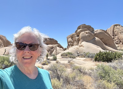
Standing in front of rocks and boulders at Joshua Tree National Park

Wilderness.  I entered through the Cottonwood entrance at the southern end of the park.  This is definitely the road less traveled. There is a visitor center about 6 miles in but there is about 30 miles of blank wilderness desert for most of the road to get to the heart of Joshua Tree National Park. There are vast swaths of desert that lead to the Coxcomb Mountains and well beyond the immense Pinto Basin. This is all untouched land.  I didn’t expect to see so much empty arid desolate land that goes on for as far as the eye can see;  there are only a few cacti. I find the entering any National Park from the less traveled entrance has advantages because there has never been a  line and I end up traveling the park in the opposite direction from the rest of the crowd.

Cholla Cactus Garden.  This is one of the few stops and parking places when entering from the Cottonwood entrance.  When you actually walk through the Cholla Cactus Garden, it looks as if someone intentionally planted all these cacti. There were probably thousands of the cacti for miles in every direction.  The same cactus for miles.  Almost like someone planted them all to harvest them, but it’s in the middle of the desert in the middle of nowhere. It’s intimidating walking on the trail through the garden because their barbed cactus spines are easily detached or “jump” off the plant onto a passerby.  

Rock Formations.  When I turned the corner and got on Park Boulevard, the entire landscape transformed into what can only be referred to as Bedrock or the land of where the Flintstones resided.  It went from desert wilderness to jumbled rock formations.  There were hundreds of these rock piles in various sizes and dimensions. I found an interesting video on how the formations formed over millions of years but basically the tectonic plates moved and the magma eventually belched up and then cracked to create these formations.  I would drive a half mile and there would be formations and then another half mile and even more formations.  There are no bad spots to pull off and walk around; they’re all other worldly.

Joshua Trees. The plant for which the town and National Park are named is not actually a tree but a succulent Yucca Brevifolia.  19th Century Mormons named them after the biblical figure because they believed that the outstretched tree limbs guided them on their westward journey. I’m sure that there are thousands of Joshua Trees in the park and in the surrounding area. Sometimes I would see one lone tree in front of a rock formation or come across several acres of trees seemingly marching across the landscape. Some are tall with many branches and some are low to the ground with just a palm frond top.  Unusual and fascinating.

The Town. I camped in the town of Joshua Tree which seems like a desert oasis for rock climbers, artists and off grid folks. There was an enormous farmers market on the Saturday that I arrived with produce and treasures for sale. The actual main visitors center for the National Park is in the town and outside of the park itself which is very unusual. It’s a bit confusing because you have the actual plant, the town and the national park all referred to by the same name.

It was an interesting adventure through the park.  There was one area I didn’t get to visit because RVs were not recommended to drive to Keys View overlook which has a panoramic view of the Little San Bernardino Mountains.  As I learned in White Sands National Park, be sure to read if a road is recommended for RV’s, if not it’s likely  to have hairpin turns, steep inclines or, as in White Sands case, ten miles of unpaved roads across the dunes. Regardless the landscape and flora were epic. 

😱The Cruel and Stunning Death Valley

I’ve crossed the Mojave Desert several times in my life. I used to live in Northern California and either driving along I-15 to Las Vegas or I-40 to Albuquerque or Phoenix, took me through the Mojave at least ten times. I always longed to take the detour to Death Valley. It was just never practical to drive the extra 3-4 hours round trip until August of 2021. My then boyfriend Roy and I were on a coast-to-coast-to-coast trip visiting National Parks and family when we planned to head back to the East Coast. There it was. Looming in the middle of the map. A gigantic chunk in Eastern California: Death Valley. Sure…it’s August. Yeah…it’s hot. OK…it’s a long drive with very few services. But why not? When was this opportunity going to land in my lap again while I live in North Carolina? Likely never. So, Roy (having already driven some 5,000 miles) was game and off to Death Valley we went.

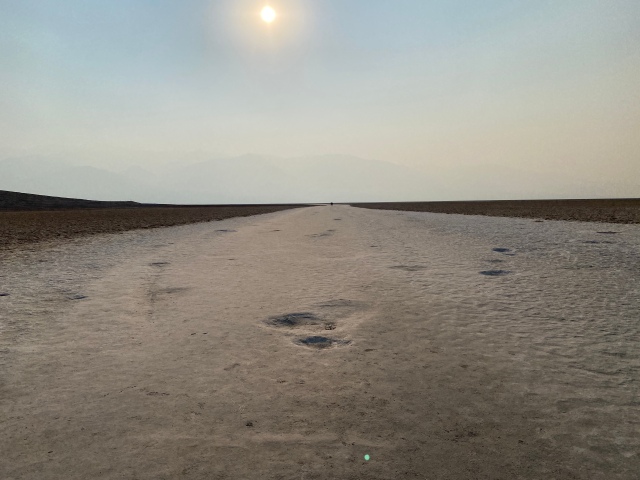
Badwater Basin at 282 feet below sea level in Death Valley

Here are some of the highlights:

Shoshone – We set off from my brother and sister-in-law’s home in Palo Alto. As we made plans the day of our travels, I searched for places to stay as we drove down I-5 on our way to Bakersfield. I found a motel that was in the town of Shoshone about 45 minutes from one of the park entrances. Shoshone was just a little dot on the map. By the time we passed through the dilapidated town of Baker, I had no cell coverage. I had no idea if the motel had even 2 stars on their reviews. I was starting to get nervous because, arriving in Shoshone after driving 500 miles into the middle of nowhere, we had no other air-conditioned options. Thankfully the Shoshone Inn was a completely renovated delightful motel. We almost opted to buy a few gallons of gas but at $5.49 per gallon, we figured that a half tank would get us to Las Vegas. If you go to Death Valley, the Shoshone Inn is a must-stay although make sure you go with a full tank of gas.

Jubilee Pass Road

We left for the park from the motel around 6 PM. We had no idea how long it would take to visit the park but we knew we at least wanted to go to Badwater Basin, so we headed out, according to the map, by the most direct route. We had no GPS as we headed on Jubilee Pass Road. It was 115 degrees, a blazing sun, a desolate road, and absolutely no other living things as we drove on a road with no signs except to instruct to stay on the road (no problem there). I was nervous. We had a few bottles of water but you start thinking about “what if’s” as you drive in such inhospitable territory. If we break down, if we get a flat tire, if the engine overheats….you get the picture. This was obviously not the main road in the park, the terrain was other worldly with its orange, yellow and white rock without vegetation or signs of life. I know what you’re thinking…. it’s not call Death Valley for its abundance in flora and fauna but the reality of driving through it is breathtaking. Scary, cruel but breathtaking.

Badwater Basin

From the motel, it took 90 minutes to arrive at Badwater Basin. 90 long, dry, hot minutes to arrive at what is the money-shot of Death Valley. This is the lowest point in North America at 282 feet below sea level.  When we arrived, it was 120 degrees. It was remarkable how the temperature climbed as we started going below sea level.  We parked and walked out on the salt flats of the evaporated “badwater”. It was oppressively hot and the wind was relentless. Buffeting winds whipped across stark salt flats and the Panamint Mountain range 10 to 11 thousand feet (obscured by smoke) loomed as a silhouette. There were two cars in the parking lot, so it was comforting to know that we were no longer alone in such an inhospitable place. High up on the valley wall was a sign that said “SEA LEVEL” which really makes you grasp how truly isolated we were.

Zabriskie Point

We decided to go back on a more heavily traveled road and stumbled on Zabriskie Point. By this time there were three cars in the parking lot (a CROWD!). A winding paved path goes up the Zabriskie Point which is named after Christian Brevoort Zabriskie, general manager of the Pacific Coast Borax Company (the company used twenty mule teams to transport borax mining operations in Death Valley). This vantage point is stunning. Again, there is no vegetation, or birds, or bugs. Just rock formations some of which look like jello molds or waves of soft ice cream. It felt like I was standing on the precipice of a cataclysmic change that had occurred many thousands of years ago and that I could have traveled by rocket ship to have witnessed it.

We only visited about a quarter of the National Park. I feel like it was just a taste. Perhaps a nibble of the entirety of the park. If you can make the trip, in a sturdy, gas-filled car with plenty of water, I would highly recommend it. I know I will be going back. The best of course is that I remembered as we arrived back at the motel that I wanted to make sure I went outside to look at the stars. Roy and I walked outside and looked up at the milky blanket of stars above. If you go, don’t forget to look up at the stunning beauty above.