🚎A Solo 10,000 Mile Sojourn

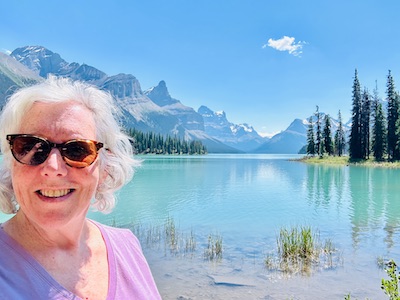
I’ve just completed a solo 10,000-mile sojourn through North America in my RV, Abeona. It’s been quite the adventure and while this was some fanciful dream just 4 months ago, I’m amazed that I actually completed it without any major snafus and that I learned so much about myself and Abeona on the journey. I visited 22 states from the deep south to the southwest, up central California to the Pacific Northwest.  I took a ferry from Bellingham, WA to Skagway, Alaska, drove through the Yukon Territory on the Alaska Highway and back down through British Columbia and Alberta, Canada with an incredible 5 days in Jasper National Park just days before the fire. I went to three countries, the US, Canada and a 90-minute trip to Las Boquillas, Mexico by crossing the Rio Grande in a row boat followed by riding a burro into the village. I’m happy to report that I can still speak Spanish relatively well.

Myself, daughter Natalie and son -in-law Kevin hiking in the Sammamish River Park

While I was planning the trip, I had a certain cadence to each week.  I worked Tuesday through Thursday and would need to have WIFI and electricity since my air conditioning only works on “shore power”.  I would find my campsites on an app/website called RV Life which shows reviews, the amenities available and the strength of the WIFI connection based on the carrier.  I had each site reserved in advance and the app would show me the route and approximate time and miles between each spot.  This was invaluable and outside of one or two changes in campsites due to visits with friends, I stuck to the route as planned. Spots that were a must see such as Big Bend National Park and Joshua Tree National Park were all planned out so I knew how much time it would take to visit each spot.  I did some detours to visit a few spots when I realized how close they were like White Sands NP, Guadalupe NP and Carlsbad Caverns NP. In all I went to 11 National Parks and 2 Canadian National Parks.  Many I had visited before but the stand out new parks were Joshua Tree NP and Theodore Roosevelt NP (where two bison were crossing the road and right by Abeona!). My favorite revisited parks were a hike with my brother Rick to Olympic NP with marmots, deer, wildflowers and snowcapped peaks, the stunning Crater Lake NP and the incredible Jasper NP and Banff NP in Canada.  

I went to several state parks including Catalina SP in Tucson, Smith Rock SP in Oregon, Big Basin SP in California with my oldest brother Dave.  Many adventures were completely unplanned and were some “might as well” sort of opportunities. I went on a glider plane ride in Tehachapi, CA because I was camped next to the runway for my workweek and decided I would be mad at myself if I didn’t give it a try.  It was terrific and completely an analog as in nothing electronic which surprised me.  Not even a radio between the guide plane and the glider. I saw signs for Shasta Caverns and decided to sign up for a tour which included a boat ride and hike through the caverns. The best adventure by far was taking a helicopter ride to the Meade glacier near Skagway AK.  I signed up to walk on the glacier but the helicopter ride was terrific through the mountains and glaciers surrounding Skagway.  I was fortunate to sit in the front seat of the helicopter and I felt like a photographer for National Geographic gliding above the glacier lakes and waterfalls. 

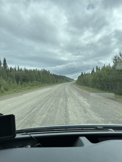
Abeona handled like a champ on scary drives like the always windy Tehachapi pass, the 11 percent grade on the Klondike Highway out of Skagway and the countless gravel roads and unmarked portions of the Alaska Highway.  I accidentally backed into a large boulder in Catalina SP which dented my sewer system. I was so fortunate that there was a remote RV repair guy in Joshua Tree that repaired it in 112-degree weather.  I had a leak in my main water inlet but my brother Dave and a call to Leisure Travel Van (the manufacturer of my RV) helped me do a fix until I got home. I also learned to manually shift coming down the dreaded Tehachapi pass, I finally figured out my tire sensors after some help from a Facebook group for Leisure Travel Vans. The only other issue was a hitchhiking mouse I picked up in the Yukon but fell victim to a trap I set months before. I learned that tire places are perfectly happy to check and fill your tires for free (thank you Les Schwab!). 

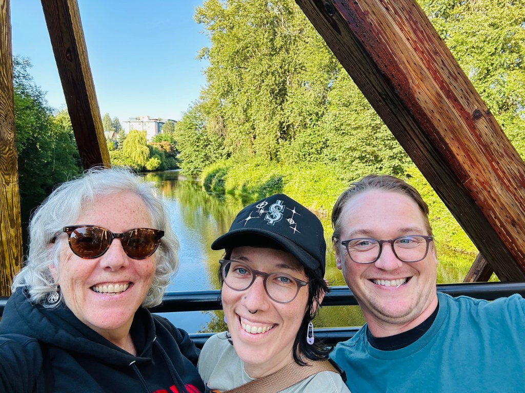
I had the opportunity to see many friends and family along the way.  I have a dear friend Tammi and her husband Larry who took me to Saguaro NP and some fantastic Mexican food in Tucson. I visited an old coworker, Jeanne at my previous employer in Scottsdale and an old elementary school friend, Michael, in Mountain View. My brother, Dave, drove me to the Redwood Groves in the Bay Area and he and his wife, Judy, hosted me for several days in Palo Alto where I was able to see my nieces and my great nieces and great nephew. I met up with my daughter and her husband along with friend, James, in Portland for incomparable vegan food. The big celebration for my mother’s 90th birthday was a relaxed trip down memory lane and some great time spent with the entire family. I met with another elementary school chum, Jim, in Fernie, BC where we took an exciting drive up a mountain in his indestructible car (Abeona would not have survived). I was able to visit my dear old friend, Johno, from my NYC days in the mid 80’s. He has a lovely lakeside house with his husband, Jim, in Indiana.  I got to see Johno do a back flip off a swim platform and I went tubing around “Lake Jimmy John” (first time I’ve done that in 20 years). I wrapped up my trip in Covington, VA visiting my Aunt Karen, her children, Craig and Kristin and her husband, Angelo, for a lovely meal in Lewisburg, WV.

I cannot tell you how many times I talked to Abeona and thanked her for being such a bad ass for getting me on and off the ferry, and for the air conditioning working for the massive back up I experienced out of Phoenix where it took two hours to go ten miles when it was 115 degrees.  There were countless evenings where the air conditioner was on all night and it never quit! There were also the tight squeezes through road signs in Palm Springs, the pouring rain near Rusk TX, and windy roads of the Olympic Peninsula. Abeona never faltered. 

My wanderlust is definitely a gene imparted from my father and so is my hesitancy towards heights. I left my father’s ashes in places he had been to and other places where he wanted to travel and sometimes when I knew it was a view he would have loved. He said in his last few years of life that Peyto Lake was the most beautiful place on earth.  I was able to travel there on this trip and leave his ashes from the overlook.  I know he would be proud of me on this cross-country sojourn and I’m proud of myself for taking it on, doing it scared and always having Daddy riding shotgun.

🫶🏻Ode to Jasper

I visited Jasper National Park and the town of Jasper from July 15th until July 19th of 2024.  It was the absolute highlight of my cross-country trip with my RV, Abeona. I traveled from South Western Texas to the Olympic Peninsula, then a ferry to Alaska and the road from Skagway to Jasper which was mostly on the Alaska Highway.  I had already traveled over 10,000 miles when I arrived in Hinton just outside Jasper National Park to camp. I usually work remotely Tuesday through Thursday and was expecting to when I realized that I didn’t have connectivity and, therefore, had to cancel all my calls for that week.  I was disappointed that I wouldn’t be working but I didn’t realize how fortuitous having four days to tour around and in Jasper National Park would be. Between the gorgeous weather, the visibility, the abundance of wildlife and 4 days all to myself to go where ever I wanted to was stupendous.

On Lake Maligne in Jasper National Park

This was not my first trip to Jasper but I didn’t realize that until I traveled southbound on the famous, scenic Icefield Highway.  The Columbia Icefields are actually in Jasper National Park because it butts up against Banff National Park to the south, I had assumed that I had only been to Banff.  Now I realize, because of the cross-country trailer trip with my family when I was 8 years old that we had gone to the Columbia Icefields, so this was my second trip here although some 50 plus years apart. 

I went into the town of Jasper which is an adorable, vacation town with coffee shops, bakeries, gift shops, all manner of tour options including rafting, snowshoeing, scenic flights, bus tours, restaurants and some 20 different hotels. The downtown is about three blocks wide and ten blocks long.  It’s easy to park and walk around. There are hanging flower pots from the light posts, totem poles, there are small parks and benches.  There is a train station in the center of town.  It’s quaint, understated, easily assessable and it’s obvious that people live there year-round and they love the place. 

My first adventure was up the Jasper Sky tram.  This is a tram up the side of the Whistlers.  There is a hiking trail at the top and the most magnificent views of all the various mountains within the Canadian Rockies but most impressively I could see the top of Mount Robson which is the highest peak in the Canadian Rockies.  Apparently, the mountain top is only visible about 10 days out of the year. 

The next day I took a tour of Maligne Canyon and Lake Maligne. There were corkscrew waterfalls down deep crevices, nesting eaglets above Medicine Lake with marmots frolicking below. Maligne Lake is an absolute mesmerizing place.  We took an hour boat ride to see Spirit Island with the “Hall of the Gods” which are the mountains as a backdrop.  It was almost a cloudless day and the beauty that surrounded us was breathtaking. We heard a loon wailing in the background and a small deer swimming across the middle of the turquoise-colored lake. It was magical.

My last tour was driving to the town of McBride past Mount Robson Provincial Park and yet another cloudless day to see the top of Mount Robson.  We took the train back from McBride which was a lovely relaxed pace to see the mountains and lakes pass by. I had to leave the next day and made my way down the Icefield Parkway and the incomprehensible string of endless jagged snowcapped mountains, mighty waterfalls and turquoise lakes that are the centerpiece of Jasper and Banff. I managed to see Peyto Lake which is what my father believed to be the most beautiful place on earth, considering all his travels in his life, it’s high praise and, outside of Spirit Island on Lake Maligne, I would have to agree.

Some 48 hours after I left Jasper and Banff, a lightning storm caused a fire that, as I write this in early August, is still not under control.  30% of the buildings in the town of Jasper were destroyed, the entire National Park and all of the residents and visitors were evacuated. It sits empty and the heartbreaking pictures of the bighorn sheep and elk roaming through the downtown streets looking for food and refuge in burned out buildings is devastating. All the tour guides and waitstaff and service folks and families that depend on them, all transplanted to who knows where. I feel like I stole a masterpiece and somehow, it’s misplaced until, ten or twenty or thirty years from now, it’s back to its original beauty.  The beauty I got to experience and now I’ve moved on to the next state and onward to home as all those truly lovely people and animals have to rebuild or move on from what is the “Jewel of Canada”.  I pray for an end to the fire and safety and health to all those affected. 

🧭Southbound on the Alaska Highway

The Alaska Highway (or Alcan: Alaska Canada Highway) runs 1,387 miles from Dawson Creek BC to Delta Junction AK.  On my trip from North Carolina to Alaska and back, I took a ferry from Bellingham, WA to Skagway, AK.  I decided on Skagway as my final port on the Alaska Marine Highway (the ferry system) because there was a road that connected to the Alaska Highway. That meant I could return down to mainland United States via the roads.  This part of my trip was by far what I was most apprehensive about before departing Durham, NC. Going solo in a 25-foot RV on some of the most remote roads in North America without a copilot, a spare tire or cell coverage is intimidating. In fact, I got about 3 hours sleep before ascending the Klondike Highway which originates in Skagway and travels up 15 miles with an 11% grade to White Pass. I was so fortunate on the morning when I departed Skagway because it was calm and foggy.  Wind, a high-profile vehicle and shear drop offs are not a good mix for me, so being shrouded in fog and stillness was actually a good thing; out of sight, out of mind.  I hooked up with the Alaska Highway in the tiny town of Carcross originally called Caribou Crossing (population 301).

Part of the Alaska Highway in the Yukon

This is what I found after traveling 855 miles on the Alaska Highway:

Wildlife. The minute I got on the Alaska Highway out of Carcross YT, I saw a moose on the side of the road.  I have waited my whole life to see a live moose (including several trips to Maine) and I was taken aback by the size of her eating along the side of the road. Just outside of Watson Lake YT, there was an entire herd of bison on both sides of the highway.  I would guess upwards of 40 bison eating along the side of the road. I saw a fox, bighorn sheep and caribou as well.  In fact, if you drive the Alaska Highway, I challenge you NOT to see wildlife. I was on high alert for most of the drive because they mark the areas where there may be wildlife present. 

Highway. I would loosely call this a highway.  There was never a section of divided, fully marked, four lane immaculately paved road.  There were sections for upwards of a mile or two where the entire width of the road was gravel due to construction.  I would bet that, especially the roadway in the Yukon (the entire population for the territory is 40,000!) and northern British Columbia, that 40% of the road was unmarked; So, passing vehicles in the opposite direction is a game of trust. I would guess that it’s about 50% trucks and 45% Recreational Vehicles on the road with motorcycles, SUVs or even a brave bicyclist for the last 5%. There were almost always ample gravel shoulders but who wants to drive 55 miles an hour on a gravel shoulder. It’s not like there was much traffic, especially in the Yukon. Canada uses completely different road signs to indicate rough road, wildlife ahead and so on. The funniest one is of a metal bridge which shows the person being rattled. There are also random box trucks left to decay but have an advertisement plastered on its side.  The highways are a unique experience. 

Services.  If I saw a gas station, I filled up.  Sometimes the road would have a warning that there weren’t services for the next 133 KM, sometimes not.  If I saw a gas pump and I still had 3/4 of a tank of gas, I still filled up. When you might see only a handful of vehicles while driving all day, the last thing I wanted was to run out of gas. I saw maybe 4 businesses (i.e. restaurants, gas stations and lodges) that were actually open between Carcross and Watson Lake. I assume that COVID wiped out a lot of the businesses up here but I ended up eating in my RV for the first two days on the Alaska Highway.  I can’t imagine not having at least a tent on this trip as I only saw a handful of lodges on the entire route. There were several businesses that hung a “closed” sign out front and most were dilapidated. I kept thinking, thank god I wasn’t depending on that place to be open.

Metric. Being fully versed in the metric system before driving the Alaska Highway would have been very helpful.  Sure, I’ve been to Europe but I have never driven in Europe.  All the signs are in kilometers which I basically just divided by two even though that is not accurate.  I was fortunate that my speedometer has metric although it’s small print.  The km per hour were constantly changing depending on the condition of the road. In addition, and probably the most startling is when a bridge would put that limit of weight in grams.  I had no idea how many grams my 11,000-pound RV was but I had to assume that the gas tanker I passed an hour ago must have gone on the same bridge.  I was definitely doing it scared. And then there were the gas stations.  I can tell you have absolutely no ideas how much gas I purchased and if I paid $2.00 a gallon or $100 a gallon.  Between liters and the Canadian dollar and the fact that the price was irrelevant if it was the only station for the next 150 miles. The metric system had me flummoxed. 

Views. I was amazed by the sheer beauty that was around each corner.  I was very fortunate that the weather was great on the four days I was traveling on the Alcan. Whether it was glacier lakes, meandering wild rivers, wildlife, miles of aspen and pine trees or the stunning views of long-lost mountains, each turn was a gift. Some rivers were bright turquoise and some were black, some groves of tress were decimated by fires and some were deep green and endless.  It’s a fascinating journey that a good portion of the world never gets to experience. I would think about pulling off on a random side road but since they were all narrow and gravel, I demurred.  The last thing I wanted to do was end up on a dead end and unable to turn around. I think of all the pictures I wanted to take but sometimes I just needed to experience regardless of whether I was able to document it.  

Dawson Creek is the end (or in most cases the beginning) of the Alaska Highway.  It’s definitely where I saw my first McDonalds in several weeks.  There are traffic lights, divided highway, neighborhoods, and the roadway is clearly marked.  All the things I take for granted back home. I am happy to report that my GPS worked for the entire route although I did have the Alcan bible, “Milepost” (a book with every highway and milepost detailed for Alaska and Western Canada). In retrospect, I’m glad I took on the journey with my RV, Abeona, because I’m so much more self-reliant.  I know that so long as I am prepared, calm and focused, I can accomplish almost anything.